This is a OCR reading of an old brochure (not yet corrected for OCR errors). Some info are obsoleted !!! This is the map.
For a better understanding of the region
The Municipality of Pylaros is located on the northeastern section of Cephalonia. It comprises of the communities of Aghia Efimia, Makryotika and Divarata. It is 34 kms from Argostoli, the capital, 35 kms from Lixouri, 28 kms from Fiskardo and 9 from Sami. It is bordered by two mountains, Aghia Dynati [1,131 m] and Kalon Oros [900 m] and coasts to the east and west. The Municipal headquarters are at Aghia Efimia from where our hiking track begins. Owing to its geographical position, Pylaros is an ideal location for visitors to explore the entire Island. The people of the region are warm and hospitable, devotees of the traditional dances and festivals. The tourism infrastructure of Pylaros meets all the requirements for the visitor to enjoy the landscape, hospitality and products of the region. It is the birthplace of Marinos Antypas a fighter for the farmers rights in Greece, and of Themos Potamianos, writer of sea stories. Themata Monastery is a place of worship and meditation of unparalleled beauty with a unique Holme oak forest. The most breathtaking sight of Pylaros is Myrtos beach which attracts thousand of tourists to its scintillating waters and lovely stretch of beach. It is one of the most beautiful beaches in the world with easy and safe access. The history of the region goes back a long way. In antiquity it was the gateway to North Cephalonia the name "Pylaros" meaning the guard of the gate. During the Mycenaean period it must have played a part in the broader Odyssean kingdom. In the classical period it was part of the city state of Sami and probably was of specific significance. Ruins at Aghia Efimia and Drakopoulata bear testament to the existence of towers for the purpose of controlling entry and exit to the valley. Roman ruins provide a glimpse of the valley's Roman history. During the Frankish occupation and the first Venetian period various movements of population occurred and new settlements were formed. From information dating back to 1678, 15 villages were registered: Makryotika, Anomeria, Divarata, Logarata, Ferendinata, Hamolakos, Themata, Megalogenata, Marketata, Gouleleta, Vasilopoulata, Bekatorata, Lekatsata, Ano & Kato Raftopoulata. At the same time numerous monasteries and churches were built. During the English occupation of the Ionian Islands Pylaros played a role in the struggle for union with Greece. Members and executives of the Radical Party, with its headquarters in Argostoli, came from this area. Citizens of Pylaros participated in the 1821 Revolution against Turks. Also provisions were sent to areas of the mainland in revolt from the port of Aghia Efimia. Lord Byron passed through Aghia Efimia via Dilinata and Falari on his way to Ithaca. Following the union of the Ionian Islands with Greece inl 864, Pylaros was subsequently able to play a significant role in the political, social and economic development of Cephalonia. From the late 19th to the early 20th Century the citizens of Pylaros struggled for the development of the region with many turning to the sea. Aghia Efimia became the commercial centre for the broader region. The majority of the population were occupied with agriculture and livestock. The cheese producers of the region spread their expertise not only throughout Greece but to the Balkans and Southern Italy. Unfortunately this progress was abruptly interrupted with the outbreak of the 2nd Wood War. Then, just as the people were trying to reorganize their lives, Civil war broke out in 1950, to be followed by the tragic devastating earthquake of 1953,causing the total disruption of the social and economic structure. Immigration became a widespread, with those remaining, persisting in rebuilding their lives. However, a relative improvement has taken place during the last decades of the 20th Century. Development programs have been implemented, revitalizing the economy and creating prospects fort rther development. The Municipality of Pylaros has played a constructive and coordinating role in this effort.
Hiking track
AGHIA EFIMIA - MYRTOS BEACH
Easy track
Duration approximately 3 hours
Follow the signs and the red indications along the track. The indicators and the text of the brochure describe the track commencing from Aghia Efimia, the seat of the Municipality of Pylaros and terminating at exquisite Myrtos beach at Divarata. The existing regional road network provides alternative routes for the return journey.
PRIMARY TRACK Part A (Aghia Efimia Krini)
Starting point
The road from the square of Aghia Efimia crosses over Diadochos Constantinos Street to a smaller square [28Th October] with plane trees and palms. Follow this road until you come to a dirt road with a sign designating the beginning of the track. Along the length of the track, stone walls covered with brambles and marking property boundaries.
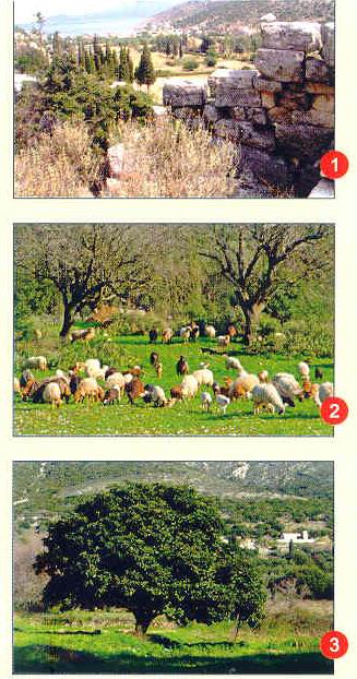
Detour (Archaeological area) At this point make a brief detour on the dirt path to the right leading to Megavouno to the remains of an ancient fortress called Palatia dating from the Hellenistic period [photo 11.
Back on the path. We continue our walk along the path that is parallel to the regional network. To the left we come to a modern private dairy factory which produces cheese and yogurt. Along the track there are pastures where the Katseno sheep, a breed unique to Cephallonia, graze [photo 2]. Further along we reach a point with two possibilities: the main path leading to Myrtos beach, or the other to XEROPOTAMOS MAKRYOTIKA [see end of brochure]. Turning right we encounter the paved regional road. Cross over to continue on the dirt road. Ahead of us lies the village of Xeropotamos with a traditional water tower built in 1955. The path continues along the gully which during the winter months becomes quite a stream. The flora of the region is impressive with huge bay and Holme oak trees creating cool dense shade, even in the height of summer. A little further along the hiker will come to a big loquat tree and behind, on the mountain slopes, the Church of Sotira with the remains of its bell tower which collapsed during the earthquake [photo 3]. Continuing among the bay, pear, and fig trees, a refuge for partridges (Perdix cefallonius, unique to the island) and black birds, we come to the provincial road to the Krini area.
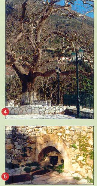
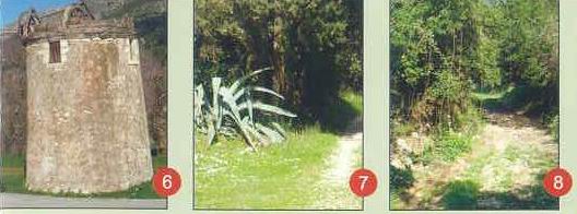
Detour [Krini Myloi] Here we have the option of two brief detours. 1st. Turning right to the asphalt road we can enjoy the shade from the centuries old plane trees whilst sitting on the wooden benches or stone troughs called limbes [photo 4]. Here stands the Church of Panaghia. A few metres along is the natural spring of Pyrgyro. 2nd. Turning left on the asphalt road we come to another cheese factory and climbing up the hill we arrive at Myloi at Potamianata and the statue of Marinos Antypas, a fighter for farmers' rights in Greece. The windmill of Papa Yiannis Sokaris was built in the 19th Century in accordance with traditional Cephalonian design, The fact that 5 out of the 7 original windmills of Pylaros still stand is testimony to quality of region's masonry and workmanship (photo 8].
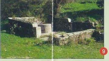
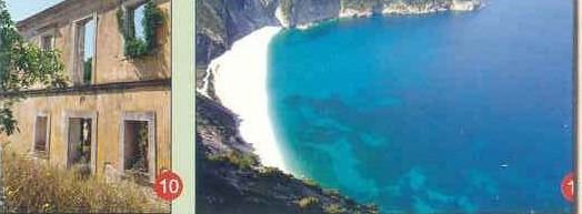
Part B (Krini Myrtos Beach) If we do not follow the detours but cross the asphalt community road we continue among the bay and pine trees until we come to a big aloe plant [photo 7]. A few metres ahead we come to an intersection and cross the road among ferns cyclamen, sweet chickpeas hryssodendra (golden trees), wild ivy, vines and mulberries [photo 8], to arrive at the Strifti stone well which was built before the earthquake [photo 9]. Although no longer in use, this well used to provide the surrounding villages with water. Climbing the hill we continue on the paved road to the village of Divarata, which was built after the destructive earthquake of 1953. To our left are the very old plane trees, Sotira Church and the remains of the old Violatos mansion, an example of Ionian architecture [photo 10]. Following the asphalt road we arrive at the main regional road to Argostoli or Fiskardo which we cross to come to Myrtos beach. Access to the beach is safe and provision has been made for the disabled. The scenery is impressive as the road winds past a gully with rich vegetation comprising myrtle, reeds and vines. In winter the gully becomes a cascade. A dive into the scintillating waters of Myrtos, with its lovely stretch of beach, is an unforgettable experience [photo 11]. The beach has all the necessary infrastructure [showers, recliners, lifeguards, toilets and a canteen]. Over a number of years the beach has been awarded the Blue Flag and operates under the supervision of the Municipal Enterprise. As an alternative we can turn right at the Church of Sotira and follow the asphalt road passing through vineyards to come to the square of Divarata arriving at the same point leading to Myrtos beach. This central road leads to the northern part of the island to the towns of Assos and Fiskardo, two other populartourist centres.
*Furthermore we can take the road that leads to the mountain Kalon Oros (4 kms), a region protected under the Natura Treaty owing to its rare fauna. At the top are remains of stone cottages, threshing floors and wells.
SECONDARY TRACK (Xeropotamos Makryotika)
This track meets the main track at Xeropotamos and turning left we notice the designating sign. Cross the Pylaros channel which starts at Mt. Aghia Dynati [ALT. 1130 ms]. Where the storm waters of the entire region gather and are then discharged into the bay of Aghia Efimia. On both sides of the gully are olive groves, wild vegetation and pastures. The track terminates at Markato in the Makryiotika region.
* If we continue straight ahead for 3 kms, we come to the mountainous region of Falari and Aghia Dynati where numerous herds of cows, goats and Katseno are organically bred.
Detour Approximately 800 m from Xeropotamos a detour leads to the main hiking path passing the windmill and statue of Marinos Antypas.
Dear visitor, This brochure will help you to discover a hiking track of exceptional natural beauty. The track connects the two main tourist areas of Pylaros, which are among the most interesting in Cefalonia Commencing from the picturesque port at Aghia Efimia and terminating at the beautiful Myrtos beach by crossing the valley between Aghia Dynati and Kalon Oros mountains
FOR FURTHER INFORMATION Please contact:
Pylaros Municipality, Aghia Efimia 28081,Cephalonia
Tel:+30 26740 61207,Fax:+30 26740 61 046
e-mail:This email address is being protected from spambots. You need JavaScript enabled to view it. or at the Public Corporation (D.E.P.T.A.Pylaros)
Tel:+30 26740 23840,Fax:+30 26740 23843
e-mail:This email address is being protected from spambots. You need JavaScript enabled to view it.
USEFUL INFORMATION
Sami Police : +30 26740 22100
Fire Brigade: +30 26740 23199
Sami Health Centre: +30 26740 22222
Sami Port Authority: +30 26740 22031
Information Kiosk: +30 26740 61774-5
Myrtos Canteen: +30 26740 61747
Taxi: +30 26740 61616
Anchorage: +30 26740 61644
Visit our website www.pylaros.gr